Category Archives: Carlson

Lambert Conformal Conic projections at ground

In keeping with the recent arcane subject series of this blog, I just finished figuring out the details of converting a SPC grid projection (like Utah South NAD83) into a ground system.

This method has the advantage of working in all software packages with a minimum number of system coefficients:

                Origin Lat, Origin Lon, False Northing, False Easting and a single Scale factor

With this method you can exactly duplicate the results you would get from traditional Modified State Plane Projection schemes that involve adding a Combined Scale Factor to a grid system with a single calibration point. While there is nothing wrong with the traditional way, the steps to implement it are different in every field software tool.

With the method that I describe, you just enter a new projection with the five coefficients and you are done.

The short explanation is:

  • Convert the 2-parallel LCC to a single parallel LCC by calculating an equivalent center latitude and the correct scale factor K0
  • Apply the correct ellipsoidial reduction factor with the correct point scale factor for the new projection base point.
  • Compute the correct false northing and easting

While some of the required coefficients are are in the NOS NGS5 SPC manual, I wanted to better understand how they are computed, so I did all the math.

I was surprised by how little information on this subject that I could find on the web, so I wrote a pretty detailed description with a worked example with all of the code that I used. Plus I used the X-PAD field software to validate the results.

If you are interested in this, continue reading this 10-page PDF:

Leave a comment

Filed under Carlson, COORDINATE STUFF, X-PAD

Carlson’s .CRDB Format Notes

The Carlson .CRD format has been around for a long time and it is fairly well documented.

The .CRDB format was released around version 5.04, but really become dependable and useful with the release of 5.06 in August 2017. The ‘new’ .CRDB format expands the size of the point name from 9-characters and the size of the point description from 31-characters to 255 characters each.

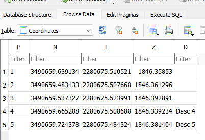
If you change the extension of the .CRDB file from .CRDB to .SQLite, then you can use any standard SQLite client (like ‘DB Browser’: https://sqlitebrowser.org/dl/#windows ) to view the structure:

The structure of a .CRDB (aka .SQLite) file.

and the contents:

Typical contents of a .CRDB file.

I am not sure if point names longer than 9 characters are a good thing and I personally have preferred 4-character point names in the range 0000 to 9999 for years, but I guess I understand STK1024, but extending the descriptions to 255 characters is certainly welcome.

There are also a lot of open source SQLite clients that make reading, writing, sorting, searching, record deletion, db compressing and cleaning for SQLite files very dependable and fast.

I don’t think there any disadvantages to making .CRDB files other than very old versions of SurvCE won’t be able to open them and many 3rd party tools are not .CRDB aware.

3 Comments

Filed under Carlson

Mark’s Spectra Precision Dealer Meeting Report

I am just back from the 2014 Spectra Precision Dealer meeting in New Orleans. It was a blast and there were plenty of BIG announcements.

The biggest announcement is the new SP80 GNSS receiver:

Image

It is about 15% smaller than the PM800 and shockingly it is a ½ lb. lighter (2.5 lbs. total) And that is with almost double the battery life. When you hold this receiver it feels right, the finish is exceptional. The design is simple.

I was impressed enough that I bought four without knowing the price and I have already sold a pair. The receiver is that good.

Best of all, first units will ship on February 20th! This is not some BS date that is going to be delayed for months, these receivers are real.

I will get into details on the SP80 below, but let me describe the BIG picture:

GNSS

Ashtech’s legendary tracking and RTK performance has not been abandoned. This receiver is Z-Blade based and it runs on $PASH commands. The Ashtech GNSS team lives.

The SP80 tracks six constellations: GPS, GLONASS, Galileo, BeiDou, QZSS and SBAS. The SP80 is unique because it will fully fix on any of five of these constellations or a mix. So you can fix GPS only, GLONASS only, or BeiDou only. Time to fix is 50% better than the PM800, about 2 seconds for a 20-km baseline.

If you don’t think this is a big deal, let me assure you it is. This morning at 10:00 am there were two GPS SV’s above 15 degrees elevation at our office. ProMark 120’s with GLONASS computed locations in seconds, while BD-970 and OEM-6 based receivers struggled for five minutes to get autonomous positions. Most (all other) receivers require a GPS only fix prior to using other constellations.

Clearly Spectra has ended up being a good home for Team-Ashtech. I can tell that they have more resources and I suspect that being part of Trimble, they can throw significantly more weight around when sourcing technology.

Software

I have been wondering about the future of FAST Survey.

Well, the next version of FAST Survey (Version 4.X) exists today. It is based on Carlson SurvCE version 3. (The version I saw was derived from SurvCE 3.80 and had been compiled on Feb 8th.) Not only does FAST 4.X support the SP-80, but it now supports the Focus 30 robot!

SurveyPro also fully supports the SP80. And SurveyPro sports a long list of new features too.

SP80 Details

Here are my notes from the meeting:

2-Year Warranty Standard. No firmware options–all options are enabled by default.

WiFi: the SP-80 has built in B-G-N WiFi so there is no need to push corrections from the data collector up to the head through the Bluetooth channel. This means you don’t need an NTRIP client in the data collector, and in fact you don’t need a data collector.

SMS Messaging (text messages) provide alerts if the batteries are low, or the base is moved.

Anti-Theft Lock: When you set a base you can lock the head. If the head is removed from the location, it locks and starts sending SMS (text) messages and email with its new location. The buttons don’t work and the only way for the thief to get the receiver to stop beeping is to pull the batteries. However when power is next applied, the head will send its location and refuse to operate.

Internal UHF Radio: 2-watt ADL. That is twice the power of most internal radios. The radio antenna connection points downwards into a special fiberglass pole which protects the UHF antenna on the rover. It is AMAZINGLY sturdy. The SP-80 has a uniform propagation pattern, this results in better range without rotating the pole. The 2-watt radio will generate a lot of heat, but it has a big finned heat sink on the head bottom that radiates the heat away from the antenna and GNSS electronics.

The USB connection is the standard mini connector and is accessible from the receiver side. The SIM and SD cards are also side accessible. Thankfully the SD card is full sized! (I can’t manipulate the micro SD cards, I really prefer the full sized cards and my new laptop has a hole that they fit into directly without an adapter.) Between the SD card and internal memory you have 31 gigabytes available. That should be plenty!

Batteries: two standard batteries. When you open the battery door (which you can do with one hand) the batteries don’t fall out on your head. The XP-80 runs for 10 hours, twice as long as an R10 but only weighs 0.17 lbs more?

The serial connector has a power input, so if you are using an external base radio, you don’t need a separate power connector to charge/power the head for extended periods.

RTK Accuracy: 8 mm, Static Accuracy: 3 mm

Tilt Sensors? The SP80 does not have tilt sensors.

Display: The SP80 display is brighter than the PM800’s and you can set it to never dim. This receiver has the best display of any receiver on the market. You can simultaneously see the SV tracked vs. used count, the battery levels, the correction latency and most importantly the Fix/Float/Auto status.

Serial Port: the serial port is pined to supply power to the head, so a base with an external radio can be directly powered from the radio’s battery without a separate cable.

IP67 (not 66!) sealed case.

Summary

This receiver is a big deal.

I can’t wait until I get my first shipment (around the 25th of February!) If you are thinking about purchasing RTK, and you operate under difficult conditions, this will be worth taking a look at.

Complete details were just made available [ here ]!

Leave a comment

Filed under Carlson, FAST Survey, Specials, Uncategorized

NAD27 UTM in “FAST Survey” and “SurvCE”

SurvCE (and FAST Survey) don’t have NAD27 UTM projections built-in. So if you are working with an older dataset (like Oil and Gas) you are going to need to enter a new projection manually.

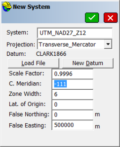
Here is how to set up for NAD27 Zone 12:

Make a new job, be sure to select ‘Meters’ (unless you want US Survey Feet or International Feet.)

0


Click on ‘Edit Projection List

0B

Press the ‘Add User Defined’ button.

2

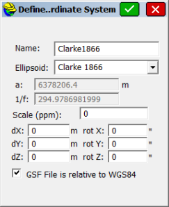
Configure to match as above. (You will need to adjust the C. Meridian to match your UTM Zone.) Then click the ‘New Datum’ button.

3

Configure to match as above.

Click the ‘Green Check Mark’ four times to return to the main menu.

Let’s check our new projection:

Now click on ‘COGO, Calculator, Conversion and put the dot in LLH->Grid’

5

Enter the lat and lon as shown above. If you entered everything correctly, then the computed Northing and Easting will be as shown.

You are now ‘Good To Go!’

M

Leave a comment

Filed under Carlson, FAST Survey

Converting a TBC Project with Local Projection to a SurvCE Job

If you have a user defined projection in TBC (or SPSO) and want to move it to SurvCE (FAST Survey), you need to duplicate the projection in SurvCE.

This document [ TBCtoSurvCE_R03 ] is a step-by-step.

Don’t freak out: you can complete the entire calibration in less than 3 minutes once you get the numbers ready to cut and paste.

Leave a comment

Filed under Carlson, FAST Survey

Nightmare on GIS Street: GNSS Accuracy, Datums and Geospatial Data

What is the difference between a reference frame, a datum and a realization?

Why is timestamping coordinates important?

What is the difference between NAD83 CORS96 and NAD83 2011?

Why don’t ESRI products support these concepts?

If you are like most people, it is all a nasty-ugly blur.

Wouldn’t it be great if someone make a simple video with really smart presenters that started to explain all of this?

Someone (Eric Gakstatter) did! And the video is great! It features Kevin Kelly the Geodesist from ESRI (who would have guessed that they had one?) Craig Greenwald and Michael Dennis from NGS who absolutely knocks it out of the park on this webinar.

This [ link ] should get you the webinar recording. You have until September 18th 2013 to watch it. Do It Now! I can not recommend this webinar highly enough! It is fantastic.

Leave a comment

Filed under Carlson, FAST Survey, GNSS Solutions

ADL Vantage Pro with “FAST Survey” or “Calrson SurvCE”: Things that match

The physical hardware port baud rate, “Serial Baud”:

Image

The physical hardware port:

Image

The ‘Radio Link Rate’ (‘Over the Air Baud Rate’) and the frequency:

Image

Notice that PDL radios have a channel 0 (zero), while ADL radios start channel numbering at 1 (one). Most users are setting Channel 0 (zero) and Channel 1 (one) to the same frequency on the PDL and then matching channel frequencies 1 through 15 on the PDL. (Not as shown above.)

Leave a comment

Filed under Carlson, FAST Survey, Uncategorized

Raw File Format

If you need to decode a Carlson Raw Data file, this is the secret ‘Decoder Ring’

http://update.carlsonsw.com/kbase_attach/372/Raw%20File%20Records_2.50.pdf

1 Comment

Filed under Carlson, FAST Survey

Connecting a Z-Max/Z-Extreme to Network/VRS/DirectIP without a GSM Module

Connecting a Legacy Z-Max to VRS Network

This method works with both ‘SurvCE’ and ‘FAST Survey’.

The easiest way to connect a Z-Max (or Z-Extreme) to a NTRIP or Direct IP is not with the factory GSM module. It is with a data collector, connected to the internet by Wi-Fi through a Mi-Fi device (or Bluetooth to cellphone,) and a serial connection from a COM port on the data collector to the Z-Max.

To use Wi-Fi you will need a data collector that has Wi-Fi and a hardwired serial port (Carlson Surveyor+.) You may alternatively use a BlueTooth connection to a cell phone and a hardwired connection to a serial port (Ashtech MMCX, MM100, PM100, PM200, Carlson Allegro.)

Continue reading

10 Comments

Filed under Carlson, FAST Survey, Uncategorized

GEOID 2012A for Ashtech GNSS Solutions and the GEOID Extract Tool

Update 11 Oct 2012: Checkout the self installer tool [ here ]

GEOID 2012A has been out for a month now.

I complied Ashtech Geoid .GEO files and have made them available for download.

http://www.alltopo.com/out/ashtech/G2012A/Geoid12A.zip

Decompress the ZIP file and then place the Geoid12A.geo file at this location (in Win7 64):

C:\Program Files (x86)\Common Files\Ashtech\Geoids

‘GNSS Solutions’ and the ‘Geoids’ extract tool will find the file the next time they are started.

If you are looking for GEOID12A for Carlson SurvCE, check out:

http://update.carlsonsw.com/kbase_main.php?action=display_topic&topic_id=843

Leave a comment

Filed under Carlson, FAST Survey, GNSS Solutions, Uncategorized